 Astronomy and space
 Atomic and molecular
 Biophysics and bioengineering
 Condensed matter
 Culture, history and society
 Environment and energy
 Instrumentation and measurement
 Materials
 Mathematics and computation
 Medical physics
 Optics and photonics
 People
 Quantum
 Scientific enterprise
Celebrating the 150th anniversary of the birth of Guglielmo Marconi, who was born on 25 April 1874.
A lack of formal education, high-powered family connections and an unstoppable will to succeed helped Guglielmo Marconi to transmit the first radio signal across the Atlantic and launch the wireless-communications industry
How to make a DIY Victorian radio
New model could explain a 50-year-old conundrum involving the Bekenstein-Hawking formula
Molecules cooled to their quantum ground state
New finding could have implications for industries that use emulsions
Understanding how glioblastoma cells transform in response to treatment, and how to stop this, could prevent recurrence of this deadly brain cancer
Material contains special bandgap states that efficiently absorb light at crucial solar wavelengths
Research could lead to the development of electrolytic computers

Find the information you need from IOP Publishing’s world-leading medical physics and biophysics journals and books, dedicated to supporting and improving research across the field, from fundamental science through to novel applications and facilities.

Eva Amsen reviews Third Millennium Thinking: Creating Sense in a World of Nonsense by Saul Perlmutter, John Campbell and Robert MacCoun
Philip Ball reviews Quantum Drama: From the Bohr-Einstein Debate to the Riddle of Entanglement by Jim Baggott and John L Heilbron
Find the information you need from IOP Publishing’s world-leading medical physics and biophysics journals and books, dedicated to supporting and improving research across the field, from fundamental science through to novel applications and facilities.
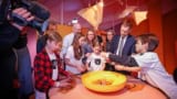 Read article: Quantum-themed escape room opens at German science museum
Game aims to teach children 10 and older about the quantum world
 Read article: Ask me anything: Florence Downs – ‘I get to satisfy my burning curiosities about new technologies’
Florence Downs is an editor at Ingenia, the Royal Academy of Engineering’s magazine for young people interested in STEM
 Read article: RayCare oncology information system enhances efficiency of cancer care
The RayCare OIS helps clinics increase the efficiency of providing quality care for cancer patients, now and into the future
 Read article: Synchronous source and measure system takes a modular approach to low-level measurement
Lake Shore Cryotronics’ M81-SSM offers DC, AC and lock-in source and measurement
 Read article: Sound and vision: synchrotron insights illuminate crystal nucleation and growth
A new take on sonocrystallization is showing industrial promise at the Diamond Light Source
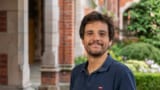
 Read article: Keith Burnett: ‘I have this absolute commitment that the broader we are, the more powerful physics will be’
Keith Burnett discusses his career, the power of diversity and the value of universities to society
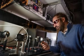
 Read article: Looking for dark matter differently
Quantum sensors made from superconducting qubits might be able to detect this mysterious substance, say physicists
 Read article: How the global gaming community is helping to solve biomedical challenges
Exploiting the efforts of millions of gamers has helped advance our knowledge of the human microbiome
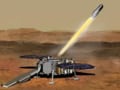 Read article: NASA demands new designs for cost-hit Mars Sample Return mission
Space agency admits that a new timeline of 2040 for the craft is “unacceptably too long”
 Read article: Local twist angles in graphene come into view
Scanning microwave impedance microscopy technique could help scientists better understand materials like twisted bilayer graphene
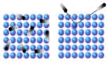
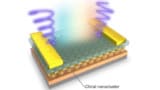
 Read article: Quantum Barkhausen noise detected for the first time
Cooperative tunnelling of spins creates magnetic "avalanches" in a crystalline quantum magnet
 Read article: US Electron-Ion Collider hits construction milestone
The Electron-Ion Collider will be built at Brookhaven National Laboratory in Long Island, New York
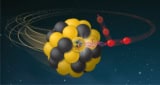
 Read article: Excitation of thorium-229 brings a working nuclear clock closer
Experiment suggests that a solid-state clock could be possible
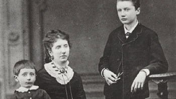
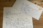 Read article: Peter Higgs: the story behind his interview with Physics World
Matin Durrani recalls the time Peter Higgs agreed to do an interview with Physics World
 Read article: Shrimp-inspired nanoclusters enable multifunctional artificial vision systems
Researchers develop nanocluster-based photoreceptors that combine colour vision, photoadaptation and circular polarization vision into a single system
 Read article: Adjuvant breast radiotherapy: KUH unlocks the clinical upsides of tangential VMAT
Tangential VMAT (tVMAT) is the treatment modality of choice for adjuvant breast radiotherapy at Kuopio University Hospital in Finland
 Read article: Mauro Paternostro: a vision of the quantum landscape
Quantum physicist Mauro Paternostro talks to Tushna Commissariat about the future of the quantum technology landscape
 Read article: Europe plans to build 100-qubit quantum computer by 2026
Funded by Quantum Delta NL, the quantum computer is expected to be made publicly available
Physics World Jobs offers a range of opportunities for jobseekers with a background in physics or engineering. At all stages of your career, we can help find the job for you
For more than 60 years, the Lawrence Livermore National Laboratory (LLNL) has applied science and technology to make the world a safer place. Its defining responsibility is ensuring the safety, security and reliability of the nation’s nuclear deterrent
Tune into online presentations that allow expert speakers to explain novel tools and applications
A live webinar on 23 April 2024 giving clinical insights into the implementation and results achieved using RadCalc and custom scripts for patient-specific QA
Stay up to date with the latest international conferences, symposia and exhibitions for interdisciplinary scientists working across academic research and industry
15—16 May 2024 | Birmingham, UK
The Advanced Materials Show is a must attend for any materials engineer, R&D professional, scientist or product developer responsible for developing, manufacturing or integrating advanced materials technology